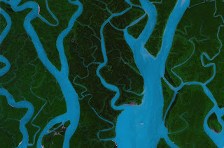
 Here are the meanders in a small tributary of the Amazon. Meanders are characteristic of rivers which are leisurely flowing through a floodplain and depositing sediment along the way.
 Here are meanders in lake Powell in Arizona, US. After the Glen Canyon dam was built, the Colorado river backed up and filled up these meanders which will remain static and unchanging.
 Here is Majuli: a river island in Brahmaputra river in India --very close to my hometown Jorhat. Note the extensive braiding pattern on the river. Before entering Assam, the Brahmaputra flows through a very steep canyon and hence carries an extensive load of sediment. This sediment is deposited on the floodplains of Assam and the sediment causes the river to subdivide into many streams which fork and rejoin leaving small islands in the middle.
The sediment deposited by the Brahmaputra is a mix of grayish-white sand mixed with a lot of organic matter. This is very different from most other rivers in Assam which deposit typical coarse brown sand. I have no idea why the colors of should differ so much.
 This is the Brahmaputra river delta in Bangladesh: Sundarban. Again notice the extensive braiding of the river channels caused by deposition of sediment before the river runs into the sea to the Bay of Bengal. The Sundarbans are known for extensive magrove forests.
 This is Redwood Shores lagoon on San Francisco bay. The brown stream empties into the San Francisco Bay. The unusual color of the water is caused by halophilic (salt-loving) bacteria. The stream presents a hierarchical branching pattern of drainage which is typically seen in much larger scale in large river systems.
 The two pictures above are from the Lena river delta. In the top picture, braiding is obvious. In the bottom picture you can see lakes in the delta with frozen boundaries.
 The San Francisco bay salt marshes are an endless source of strange colors and forms.


